Territorial Changes in Israel and Palestine
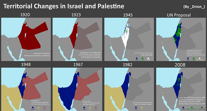
Territorial changes in Israel and Palestine since 1920 have been a central aspect of the Israeli-Arab conflict, characterized by a complex history of shifting borders, disputes, and competing claims. The early part of the 20th century saw significant changes in the region, leading to the establishment of the modern state of Israel and the ongoing challenges in the Israeli-Palestinian conflict.
In the aftermath of World War I, the League of Nations granted Britain a mandate over the territory known as Palestine. During this period, Jewish immigration to Palestine increased as part of the Zionist movement, which aimed to establish a Jewish homeland. Tensions between Jewish and Arab communities grew, resulting in periodic violence and clashes.
The United Nations proposed a partition plan in 1947 to create separate Jewish and Arab states, but it was rejected by Arab leaders, leading to a war in 1948. After the war, Israel declared independence and expanded its territory beyond the borders proposed in the partition plan. The neighboring Arab states also captured territories. The armistice lines established after this conflict left Israel in control of a significant portion of land, including the western part of Jerusalem.
In 1967, the Six-Day War resulted in further territorial changes. Israel captured the West Bank and East Jerusalem from Jordan, the Gaza Strip and the Sinai Peninsula from Egypt, and the Golan Heights from Syria. These gains expanded Israeli control and created a more complex situation regarding Palestinian and Arab land.
Efforts to resolve the conflict and define borders have taken place over the years, notably through the Oslo Accords in the 1990s. These agreements led to the establishment of the Palestinian Authority and a division of the West Bank into areas controlled by Israel and areas administered by the Palestinian Authority. However, final status agreements, including border delineations, have not been reached, leading to ongoing disputes and clashes.
The atlas of tiny maps below, created by Reddit user Drion, illustrates the primary stages of territorial change in Israel and Palestine.

